BENEFITS
Accidents and damage to containers cost money, because operators have to spend time investigating incidents, repairing the damage and re-training RTG operators to help prevent such incidents from re-occurring. Once auto-steering has been introduced, the operator needs simply concentrate on moving containers.
Many RTG operators used to manual operation don't like to admit that automated systems can do the job better than they can, although they quickly learn that there are real benefits and improvements to be had from the enhanced working environment and therefore the new systems are usually embraced quite quickly.
Auto-steering does dramatically cut the number of accidents and near misses which are the result of operators not steering an RTG accurately. This, in turn, frees them up to concentrate on other aspects of driving, such as looking out for trucks passing close by.
Nevertheless, he adds that auto-steering does not make operators redundant, pointing out that driverless operation would require significantly more on board automation.
The main features of the AutoSteering module are:
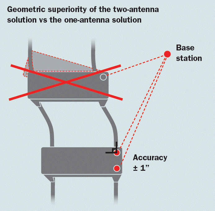
- Dual antenna dual-frequency DGPS receiver for accuracy and redundancy
- Dual DGPS receiver antennas on the opposite ends of the gantry for accurate heading determination
- Full integration to PLC systems
- Automatic slow-down/fast ramp-down in the event of excessive deviation
- productivity at the port rose by over 25% in the first year.
- The high-precision guidance created more uniformly aligned container rows allowing for easier placement and retrieval of containers.
- Improvements to the line “maps” reduced crane collisions with yard infrastructure (i.e. light poles, trains, etc.) and greatly increased operational safety.
- Mobile Computer – The unit is about a third of the size of the Second-Generation system. The satellite unit and analog card are securely mounted on a PC104 stack.
- Positioning System – The NovAtel dual-antenna, multi-frequency OEM7720 offers future-ready precise heading and positioning for space constrained applications. Advanced interference mitigation features maintain high performance in challenging environments. The system with only GPS and Glonass doubles the number of visible satellites that can be tracked. The OEM7720 is capable of tracking all current and upcoming GNSS constellations including GPS, GLONASS, Galileo, BeiDou, QZSS and NavIC.
- 900 MHz radio – the radio is separated into its own waterproof enclosure. The radio system is dedicated to transmitting only radio corrections. This means radios can be interchanged between installations with no re-programming required.
- Wi-Fi Communications – The system is designed for two-way communication over the internet. Remote access is used to retrieve data from the system and update yard maps, setup files, and system firmware.
- User Interface – The system uses web-based browsers for viewing real-time information either over Wi-Fi or thru a direct ethernet connection in the crane. Set- up files, yard maps and software updates can easily be uploaded remotely without the requirement to physically take a laptop to the crane.
- Base Station Software – Running in the customer's network, a Linux Server hosts web-based software for real-time viewing of all crane locations and status on zoomable maps overlaid with detailed yard information. Each crane user interface is directly accessible from the base station software.
- Yard Map – The GCGS system can be used for collecting data to update or create new virtual lines.
- Geofences – The GCGS includes the ability to create Geofence zones to be added to the yard map. This allows cranes to be controlled differently depending on which area they are operating in.


